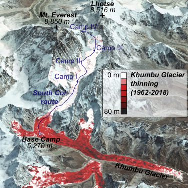
This data set provides elevation change maps in GeoTIFF format of the Everest region, including the Barun, Rongbuk and Kangshung glaciers.
Reference: King, O., Bhattacharya, A., Ghuffar, S., Tait, A., Guilford, S., Elmore, A. C., & Bolch, T. (2020). Six Decades of Glacier Mass Changes around Mt. Everest Are Revealed by Historical and Contemporary Images. One Earth, 3(5), 608–620. https://doi.org/10.1016/j.oneear.2020.10.019
When using this dataset, please cite the above reference (King et al., 2020).