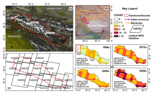
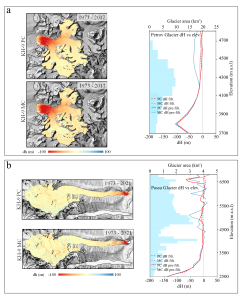
Multi-temporal glacier inventories provide key information about the glaciers, their characteristics, and changes and are inevitable for glacier modelling and investigating geodetic mass changes. However, to date, no consistent multi-temporal glacier inventory for the whole of the Karakoram exists, negatively affecting the monitoring of spatio-temporal variations in glaciers’ geometric parameters and their related applications. We used a semi-automatic method combining automatic segmentation and manual correction and produced a multi-temporal Karakoram glacier inventory (KGI) compiled from Landsat TM/ETM+/OLI (Thematic Mapper, Enhanced Thematic Mapper Plus, and Operational Land Imager) images for the 1990s, 2000s, 2010s, and 2020s. Our assessments using independent multiple digitisation of 37 glaciers show that the KGI is sufficiently accurate, with an overall uncertainty of ±3.68 %. We also performed uncertainty evaluation for the contiguous glacier polygons using a buffer of half a pixel, which resulted in an average mapping uncertainty of ±5.21 %. We calculated more than 20 attributes for each glacier, including coordinates, area, supraglacial debris area, date information, and topographic parameters derived from the ASTER GDEM (Advanced Spaceborne Thermal Emission and Reflection Radiometer global digital elevation model). According to KGI-2020s, approximately 10 500 alpine glaciers (>0.01 km2 each) cover an area of 22 510±828 km2 of which 10.18±0.38 % (2290±84 km2) is covered by supraglacial debris. Over the past 3 decades, the glaciers experienced a loss of clean ice and/or snow area but a gain in supraglacial debris. Supraglacial debris cover has increased by 17.63±1.44 % (343.30±27.95 km2), while non-debris-covered glaciers decreased by 1.56±0.24 % (319.85±49.92 km2). The total glacier area was relatively stable and showed only a slight insignificant increase of 23.45±28.85 km2 (0.10±0.13 %). The glacier area has declined by 3.27±0.24 % in the eastern Karakoram, while the glacier area slightly increased in central (0.65±0.10 %) and western Karakoram (1.26±0.11 %). Supraglacial debris has increased over the whole of Karakoram, especially in areas above 4200 m a.s.l. (above sea level), showing an upward shift. The glacier area changes were characterised by strong spatial heterogeneity, influenced by surging and advancing glaciers. However, due to global warming, the glaciers are on average retreating. This is in particular true for small and debris-free glaciers. The multi-temporal KGI data are available at the National Cryosphere Desert Data Center of China: https://doi.org/10.12072/ncdc.glacier.db2386.2022 (F. Xie et al., 2022).
New article: Interdecadal glacier inventories in the Karakoram since the 1990s
You Might Also Like
New article: Glacier mapping and change estimation using very high-resolution declassified Hexagon KH-9 panoramic stereo imagery (1971–1984)