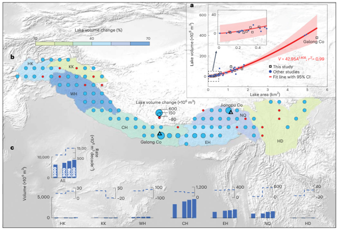
Long-term satellite-based observations have helped quantify glacier mass change and the response of the hydrosphere to glacier changes. However, subaqueous mass loss associated with lake-terminating glaciers is not accounted for in geodetic methods, leading to an underestimation of glacier mass loss. Here we use multi-temporal satellite data and an empirical area–volume relationship to estimate the volume change of glacial lakes across the greater Himalaya and quantify subaqueous mass loss due to the replacement of ice with lake water. We show that proglacial lakes have increased 47% by number, 33 ± 2% by area and 42 ± 14% by volume from 2000 to 2020. The expansion of glacial lakes has resulted in 2.7 ± 0.8 Gt of subaqueous mass loss between 2000 and 2020, such that the previous estimate of total mass loss of lake-terminating glaciers in the greater Himalaya is underestimated by 6.5 ± 2.1%. Regionally, the largest underestimation (10 ± 4%) occurred in the central Himalaya, where glacial lake growth has been the most rapid. Our estimates reduce uncertainties in total glacier mass loss, provide important data for glacio-hydrological models and therefore also support the water recources management in this sensitive mountain region.